
- SAP Community
- Products and Technology
- Supply Chain Management
- SCM Blogs by SAP
- Premium Hub CoE – DSC Knowledge Bits – “A simple s...
Supply Chain Management Blogs by SAP
Expand your SAP SCM knowledge and stay informed about supply chain management technology and solutions with blog posts by SAP. Follow and stay connected.
Turn on suggestions
Auto-suggest helps you quickly narrow down your search results by suggesting possible matches as you type.
Showing results for
Advisor
Options
- Subscribe to RSS Feed
- Mark as New
- Mark as Read
- Bookmark
- Subscribe
- Printer Friendly Page
- Report Inappropriate Content
12-28-2023
11:56 AM
Table of Contents
1 Introduction.
2 Technical Background
3 Setup RFC Destination to connect HSS
3.1 RFC Destination for HSS Authentication
3.2 RFC Destination for HSS Connection
4 Process Controller settings for HSS
4.1 Strategy and Method
4.2 Process Controller Parameter
4.2.1 Define Parameter
4.2.2 Assign Parameters to a Method
4.2.3 Assign Method Parameters to a Strategy
5 Application configuration to use GIS service
5.1 Basic Settings
5.2 Assign Geo-Coding Strategy to Geo-Coding level
5.3 Assign Geo-Coding level to Distance and Duration Determination Strategy
5.4 Assign Geo-Routing for Map
6 Testing
7 Conclusion
8 Reference
SAP HANA Spatial Services (HSS) with Matrix Routing capability can significantly enhance Transportation Management for SAP S/4HANA, offering various benefits to optimize routing and achieve substantial cost savings, particularly when dealing with large volumes of data.
This blog aims to elucidate the simple setup guide to integrate Transportation Management with SAP HANA spatial services (HSS), specifically focusing on applications such as Geo-Coding, Distance and Duration Determination, and Geo-Routing.
To enable the consumption of SAP HANA spatial services a subscription to an SAP HANA Spatial Service instance is required. Please refer to the respective SAP HANA Spatial Services Onboarding Guide | SAP Help Portal.
Having the HSS connector class /SCMB/CL_GIS_CONNECTOR_SCP in the system is essential. Install a service pack that includes the class or implement "SAP Note 2711181-GIS Connector SCP Spatial Services". Verify for any applicable corrections mentioned in “"SAP Note 2711181-GIS Connector SCP Spatial Services" or available on components SCM-BAS-LDD or, more recently, TM-MD-TN-HSS. To take advantage of additional performance optimizations and new features, ensure the implementation of "SAP Note 3261879-HSS integration: performance improvements"(supported from SAP Note 2813859-SAP S/4HANA 1909 Supply Chain for Transportation Management onwards).
The following RFC destinations need to be maintained to enable the use of the HSS integration. An example text file snapshot for service key is shown here to help you locate the correct values.
Transaction: SM59 – Configuration of RFC Destinations
Technical Settings
Logon & Security
Technical Settings
Logon & Security

The HSS GIS Connection is done using the Process Controller Framework. Standard SAP delivered following strategy for DDD, Geo-Coding and Geo-Routing.
The method assignment to above strategies as per following.
The assignment of methods and classes for HANA spatial services is as follows, while the Buffer check and update method still employs the old DDD connector class.
Several parameters are available, but these depend on the requirements of the GIS provider—what they need and what they can offer. I will emphasize the mandatory parameter crucial for integrating with HSS. For detailed information about all other parameters, you can refer to "SAP Note 2751622-Setup Guide for SAP HANA Spatial Services in SCE Applications", which serves as a comprehensive setup guide for SAP TM and HSS.
Customizing: Transportation Management-> Basic Functions-> Process Controller-> Define Parameters
Distance and Duration
Assign parameter name SCP_SS_DD_VENDOR and SCP_SS_DD_VENDOR_P1 to the service of Distance and Duration determination DDD_DET.
Geo-Coding
Assign parameter name SCP_SS_GC_VENDOR and SCP_SS_GC_VENDOR_P1 to the service of Geo-Coding GEO_DET.
Geo-Routing
Assign parameter name SCP_SS_GR_VENDOR and SCP_SS_GR_VENDOR_P1 to the service of Geo-Routing GEO_ROUTE.
As you can see in all services the parameter Vendor name and Vendor Parameter 1 is mandatory. Please keep in mind the parameter type is “Character String”.
Now we must assign those parameters to the method of DDD, Geo-Coding and Geo-Routing.
Customizing: Transportation Management-> Basic Functions-> Process Controller-> Assign Parameters to a Method
Finally, comes the significant step where we must assign these method parameters to the strategy along with their respective values.
Customizing: Transportation Management-> Basic Functions-> Process Controller-> Assign Method Parameters to a Strategy
Vendor Name:
In this example I have taken GIS vendor as “Here” which is connected to HSS.
Vendor Parameter 1:
The API key for the "Vendor Parameter 1" will depend on the type of contract you have subscribed to for utilizing HANA HSS.
If your customer already holds a license with a GIS provider, such as HERE, the value for the api_key should be the HERE API Key. Obtain this information from your provider and input it accordingly.
On the other hand, if you have an SAP Global OEM contract with HERE, the value for the api_key should be "SAP-KEY" (hardcoded).
For more information regarding contract type use the link Frequently Asked Questions for SAP HANA Spatial Services | SAP Help Portal
A prerequisite for the usage of the HSS integration is a working setup of the GIS Integration Framework. This involves the following settings.
Customizing: : Master Data -> Transportation Network -> Location -> Geocoding->Define Geocoding Levels
Customizing: Master Data -> Transportation Network -> Transportation Lane -> Distance and Duration Determination->Define Strategy for Distance and Duration Determination and Georouting
Note: MTR is optional.
Customizing: : Basic Functions -> Geographical Map -> Define Settings for Geographical Map
To use map Geographical map service, refer to "SAP Note 3234613-OAuth based authentication in Visual Business".
Geo-Coding
Test the HSS strategy for Geo-Coding using report /SCMB/TEST_GEO_CODING.
Distance Determination
Test the HSS strategy for Geo-Coding using report /SCMB/TEST_DDD.
Geo-Routing
Optimal testing for Geo-Routing within SAP Transportation Management can be performed in the Transportation Network Cockpit. Choose two locations in countries where Geo-Routing is supported by the designated GIS vendor. Simply drag and drop one location onto the other, and as a result, a real-street route will be displayed.
By following this step-by-step guide, organizations can seamlessly integrate Transportation Management for SAP S/4HANA with SAP Hana Spatial Service, leveraging the power of spatial data with matrix routing concept for optimized logistics and transportation management. Embrace this integration to enhance decision-making and efficiency in your supply chain operations.
Learn more about How SAP HANA Spatial Services is used within SAP applications
Learn more about MKS 86-GIS Integration for SCE Applications using SAP Cloud Platform
Learn more about 2 Key features of SAP Transportation Management with integration to Cloud Services: SAP HSS service ...
Demo video showing use of HSS within SAP TM application.
Discover further insights into SAP Premium Engagement and explore how an international team of specialists can assist you in maximizing the value of your SAP solutions.
If you already are a Premium Engagement customer, contact your Technical Quality Manager (TQM) to discuss how Premium Engagement Service can help you with a custom-tailored and efficient service portfolio to make your project a success!
1 Introduction.
2 Technical Background
3 Setup RFC Destination to connect HSS
3.1 RFC Destination for HSS Authentication
3.2 RFC Destination for HSS Connection
4 Process Controller settings for HSS
4.1 Strategy and Method
4.2 Process Controller Parameter
4.2.1 Define Parameter
4.2.2 Assign Parameters to a Method
4.2.3 Assign Method Parameters to a Strategy
5 Application configuration to use GIS service
5.1 Basic Settings
5.2 Assign Geo-Coding Strategy to Geo-Coding level
5.3 Assign Geo-Coding level to Distance and Duration Determination Strategy
5.4 Assign Geo-Routing for Map
6 Testing
7 Conclusion
8 Reference
1 Introduction
SAP HANA Spatial Services (HSS) with Matrix Routing capability can significantly enhance Transportation Management for SAP S/4HANA, offering various benefits to optimize routing and achieve substantial cost savings, particularly when dealing with large volumes of data.
This blog aims to elucidate the simple setup guide to integrate Transportation Management with SAP HANA spatial services (HSS), specifically focusing on applications such as Geo-Coding, Distance and Duration Determination, and Geo-Routing.
To enable the consumption of SAP HANA spatial services a subscription to an SAP HANA Spatial Service instance is required. Please refer to the respective SAP HANA Spatial Services Onboarding Guide | SAP Help Portal.
2 Technical Background
Having the HSS connector class /SCMB/CL_GIS_CONNECTOR_SCP in the system is essential. Install a service pack that includes the class or implement "SAP Note 2711181-GIS Connector SCP Spatial Services". Verify for any applicable corrections mentioned in “"SAP Note 2711181-GIS Connector SCP Spatial Services" or available on components SCM-BAS-LDD or, more recently, TM-MD-TN-HSS. To take advantage of additional performance optimizations and new features, ensure the implementation of "SAP Note 3261879-HSS integration: performance improvements"(supported from SAP Note 2813859-SAP S/4HANA 1909 Supply Chain for Transportation Management onwards).
3 Setup RFC Destination to connect HSS
The following RFC destinations need to be maintained to enable the use of the HSS integration. An example text file snapshot for service key is shown here to help you locate the correct values.
Transaction: SM59 – Configuration of RFC Destinations
3.1 RFC Destination for HSS Authentication
Technical Settings
| RFC Destination | SCP_SPATIAL_OAUTH |
| Connection type | G |
| Description | SAP HANA spatial services OAUTH Destination |
| Host | “URL” from service key of your HSS instance (Indicated by arrow) |
| Port | 443 |
| Path Prefix | /oauth/token |
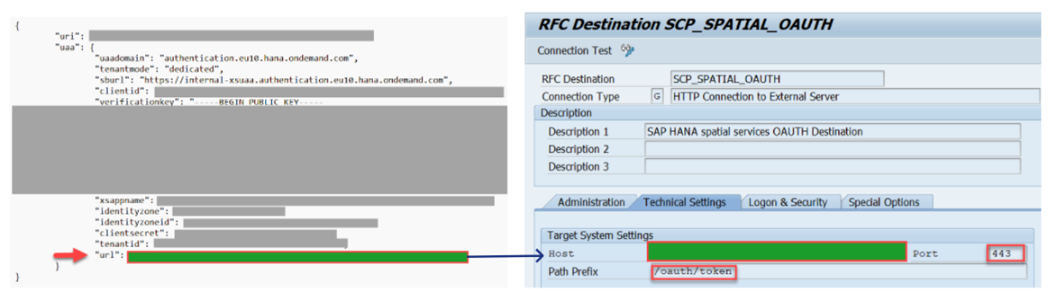
Fig 1: Mapping of Service key into RFC destination
Logon & Security
| Logon with User | Basic Authentication |
| User | “clientid” from service key of your HSS instance (Indicated by arrow) |
| Password | “clientsecret” from service key of your HSS instance (Indicated by arrow) |
| Logon with Ticket | Do Not Send Login Ticket |
| SSL | Active |
| SSL Certificate | ANONYM SSL Client |

Fig 2: Mapping of Service key into RFC destination
3.2 RFC Destination for HSS Connection.
Technical Settings
| RFC Destination | SCP_SPATIAL |
| Connection type | G |
| Description | SAP HANA spatial services Target Destination |
| Host | “URI” from service key of your HSS instance (Indicated by arrow) |
| Port | 443 |

Fig 3: Mapping of Service key into RFC destination
Logon & Security
| Logon with User | Do not use a user. |
| Logon with Ticket | Do Not Send Login Ticket |
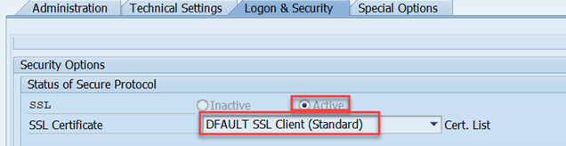
| SSL | Active |
| SSL Certificate | DFAULT SSL Client |
Fig 4: Logon and Security settings for RFC destination
4 Process Controller settings for HSS
4.1 Strategy and Method
The HSS GIS Connection is done using the Process Controller Framework. Standard SAP delivered following strategy for DDD, Geo-Coding and Geo-Routing.

Fig 5: Strategy for DDD, Geo-Coding and Geo-Routing
The method assignment to above strategies as per following.

Fig 6: Method assignment to the strategy
The assignment of methods and classes for HANA spatial services is as follows, while the Buffer check and update method still employs the old DDD connector class.

Fig 7: HSS class and method
4.2 Process Controller Parameter
Several parameters are available, but these depend on the requirements of the GIS provider—what they need and what they can offer. I will emphasize the mandatory parameter crucial for integrating with HSS. For detailed information about all other parameters, you can refer to "SAP Note 2751622-Setup Guide for SAP HANA Spatial Services in SCE Applications", which serves as a comprehensive setup guide for SAP TM and HSS.
4.2.1 Define Parameter.
Customizing: Transportation Management-> Basic Functions-> Process Controller-> Define Parameters
Distance and Duration
Assign parameter name SCP_SS_DD_VENDOR and SCP_SS_DD_VENDOR_P1 to the service of Distance and Duration determination DDD_DET.

Fig 8: Parameters for DDD Service
Geo-Coding
Assign parameter name SCP_SS_GC_VENDOR and SCP_SS_GC_VENDOR_P1 to the service of Geo-Coding GEO_DET.

Fig 9: Parameters for Geo-Coding Service
Geo-Routing
Assign parameter name SCP_SS_GR_VENDOR and SCP_SS_GR_VENDOR_P1 to the service of Geo-Routing GEO_ROUTE.

Fig 10: Parameters for Geo-Routing Service
As you can see in all services the parameter Vendor name and Vendor Parameter 1 is mandatory. Please keep in mind the parameter type is “Character String”.
4.2.2 Assign Parameters to a Method
Now we must assign those parameters to the method of DDD, Geo-Coding and Geo-Routing.
Customizing: Transportation Management-> Basic Functions-> Process Controller-> Assign Parameters to a Method

Fig 11: Assign parameters to Method for DDD

Fig 12: Assign parameters to Method for Geo-Coding

Fig 13: Assign parameters to Method for Geo-Routing
4.2.3 Assign Method Parameters to a Strategy
Finally, comes the significant step where we must assign these method parameters to the strategy along with their respective values.
Customizing: Transportation Management-> Basic Functions-> Process Controller-> Assign Method Parameters to a Strategy

Fig 14: Assign Method parameters to Strategy for DDD, Geo-Coding and Geo-Routing
Vendor Name:
In this example I have taken GIS vendor as “Here” which is connected to HSS.
Vendor Parameter 1:
The API key for the "Vendor Parameter 1" will depend on the type of contract you have subscribed to for utilizing HANA HSS.
If your customer already holds a license with a GIS provider, such as HERE, the value for the api_key should be the HERE API Key. Obtain this information from your provider and input it accordingly.
On the other hand, if you have an SAP Global OEM contract with HERE, the value for the api_key should be "SAP-KEY" (hardcoded).
For more information regarding contract type use the link Frequently Asked Questions for SAP HANA Spatial Services | SAP Help Portal
5 Application configuration to use GIS service.
A prerequisite for the usage of the HSS integration is a working setup of the GIS Integration Framework. This involves the following settings.
5.1 Basic Settings
- Enable the “Set Usage of GIS Tool” Flag in customizing: Master Data ->Transportation Lane -> Distance and Duration Determination -> Set Usage of GIS Tool

Fig 15: GIS tool usage for DDD
- The relevant Means of Transport requires an enabled “GIS Quality” flag.

Fig 16: GIS quality flag for MtR
- The speed profile number range object /SAPAPO/SP requires the creation of an interval as a prerequisite for the buffering of distances and duration.
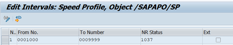
Fig 17: Speed Profile
5.2 Assign Geo-Coding Strategy to Geo-Coding level.
Customizing: : Master Data -> Transportation Network -> Location -> Geocoding->Define Geocoding Levels

Fig 18: Assign Geo-Coding strategy to Geo-Coding level
5.3 Assign Geo-Coding level to Distance and Duration Determination Strategy
Customizing: Master Data -> Transportation Network -> Transportation Lane -> Distance and Duration Determination->Define Strategy for Distance and Duration Determination and Georouting

Fig 19: Assign Gep-Coding level to DDD Strategy
Note: MTR is optional.
5.4 Assign Geo-Routing for Map
Customizing: : Basic Functions -> Geographical Map -> Define Settings for Geographical Map
To use map Geographical map service, refer to "SAP Note 3234613-OAuth based authentication in Visual Business".
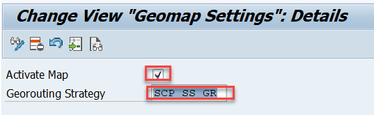
Fig 20: Enable Map for Geo-Routing
6 Testing
Geo-Coding
Test the HSS strategy for Geo-Coding using report /SCMB/TEST_GEO_CODING.
Distance Determination
Test the HSS strategy for Geo-Coding using report /SCMB/TEST_DDD.
Geo-Routing
Optimal testing for Geo-Routing within SAP Transportation Management can be performed in the Transportation Network Cockpit. Choose two locations in countries where Geo-Routing is supported by the designated GIS vendor. Simply drag and drop one location onto the other, and as a result, a real-street route will be displayed.
7 Conclusion
By following this step-by-step guide, organizations can seamlessly integrate Transportation Management for SAP S/4HANA with SAP Hana Spatial Service, leveraging the power of spatial data with matrix routing concept for optimized logistics and transportation management. Embrace this integration to enhance decision-making and efficiency in your supply chain operations.
8 Reference
Learn more about How SAP HANA Spatial Services is used within SAP applications
Learn more about MKS 86-GIS Integration for SCE Applications using SAP Cloud Platform
Learn more about 2 Key features of SAP Transportation Management with integration to Cloud Services: SAP HSS service ...
Demo video showing use of HSS within SAP TM application.
Discover further insights into SAP Premium Engagement and explore how an international team of specialists can assist you in maximizing the value of your SAP solutions.
If you already are a Premium Engagement customer, contact your Technical Quality Manager (TQM) to discuss how Premium Engagement Service can help you with a custom-tailored and efficient service portfolio to make your project a success!
- SAP Managed Tags:
- SAP Transportation Management,
- SAP HANA Spatial,
- SAP Business Technology Platform
Labels:
1 Comment
You must be a registered user to add a comment. If you've already registered, sign in. Otherwise, register and sign in.
Labels in this area
-
Business Trends
169 -
Business Trends
24 -
Catalog Enablement
1 -
Event Information
47 -
Event Information
4 -
Expert Insights
12 -
Expert Insights
39 -
intelligent asset management
1 -
Life at SAP
63 -
Product Updates
500 -
Product Updates
66 -
Release Announcement
1 -
SAP Digital Manufacturing for execution
1 -
Super Bowl
1 -
Supply Chain
1 -
Sustainability
1 -
Swifties
1 -
Technology Updates
187 -
Technology Updates
17
Related Content
- SAP Business Network for Logistics 2404 Release – What’s New? in Supply Chain Management Blogs by SAP
- SAP IBP Real-Time Integration: Empowering Businesses for Smarter, Faster Decisions in Supply Chain Management Blogs by SAP
- Premium Hub CoE – DSC Knowledge Bits Series in Supply Chain Management Blogs by SAP
- AI-powered supply chain solutions: Better decisions, better outcomes in Supply Chain Management Blogs by SAP
- RISE with SAP Advanced Logistics Package in Supply Chain Management Blogs by SAP
Top kudoed authors
| User | Count |
|---|---|
| 8 | |
| 7 | |
| 6 | |
| 4 | |
| 4 | |
| 4 | |
| 4 | |
| 3 | |
| 3 | |
| 3 |